Trail Winter sports Wohlen bei Bern - Wohleibeiz - Photo
 remo
remo

User

© OpenStreetMap contributors
Length
Length
23 km
Max alt
Max alt
661 m
Uphill gradient
Uphill gradient
532 m
Km-Effort
Km-Effort  
30 km
Min alt
Min alt
480 m
Downhill gradient
Downhill gradient
589 m
Boucle
Boucle
No
Creation date :
2014-12-11 00:00:00.0
Updated on :
2014-12-11 00:00:00.0

(0 Reviews)

Winter sports
Winter sports
--
Difficulty : Unknown

Scan this QR Code to open this trail in the SityTrail application

FREE GPS app for hiking

Logo SityTrail SityTrail

IGN / Geographical institutes

Download SityTrail from the App Store Download SityTrail from Google Play

Logo SityTrail SityTrail Plus

The world is yours!

Download SityTrail from the App Store Download SityTrail from Google Play Download SityTrail on Huawei AppGallery

About

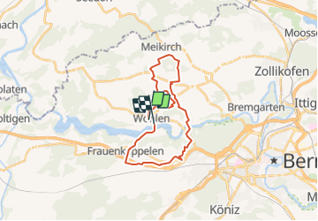
Trail Winter sports of 23 km to be discovered at Bern, Bern-Mittelland administrative district, Wohlen bei Bern. This trail is proposed by remo.

Description

Von Wohlen Schulhaus-Oberwohlen-Schüpfenried-Meikirch-Uettligen-Stegmattsteg-Jorde-Gäbelbach-Frauenkappelen-Katzenstieg-Wohleibrücke-Wohleibeiz.

Anmerkung: Es gäbe auch einen direkteren Weg...  ;-)

Elevation profile

Positioning

Country:
Switzerland
Region :
Bern
Department/Province :
Bern-Mittelland administrative district
Municipality :
Wohlen bei Bern
Location:
Unknown
Start:(UTM)
374802 ; 5203149 (32T) N.


Close
My subscriptions